Locally severe storms to rattle part of Northeast into Tuesday night
Part of the same storm system responsible for days of severe weather in the central United States will affect the Northeast into Tuesday night with thundery downpours and gusty consequences, AccuWeather meteorologists alert.
“The combination of a front moving in from the Midwest and cooling at the middle levels of the atmosphere will provide an ingredient for potent thunderstorms to erupt from the eastern Great Lakes and the central Appalachians to part of the mid-Atlantic region into Tuesday night,” AccuWeather Regional Expert Meteorologist Dave Dombek said.
The storms will not have the same intensity as they did in the Heartland Friday to Saturday, so a significant outbreak of severe weather is not expected in the Northeast.
“If there was a strong cold front moving in with dramatic cooling going on upstairs in the atmosphere, it could be a much more serious situation for the Northeast,” Dombek said.
The storms can still pack a punch in parts of Pennsylvania, upstate New York, West Virginia, Maryland, Virginia and New Jersey. This includes Philadelphia, Harrisburg and Scranton, Pennsylvania; Syracuse and Binghamton, New York; Hagerstown, Maryland; and Winchester, Virginia. Some heavy, gusty thunderstorms will reach the northern and western suburbs of New York City, Washington, D.C., and Baltimore and could find their way through the cities.
“Incidents of damaging wind gusts, hail and torrential downpours are likely in some of the storms in the Northeast,” AccuWeather Senior Meteorologist Matt Benz said, adding, “There will be a bit of a protective cool barrier in part of the region.”
The barrier Benz refers to is a layer of cool, dense air in the lower part of the atmosphere — nearest the ground.

This will prevent powerful wind gusts from thunderstorms from reaching the ground. However, there can still be drenching downpours, thunder and lightning and hail in some cases.
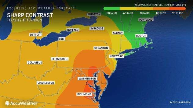
This boundary separating temperatures in the 50s and 60s from readings in the 70s, 80s and near 90 will extend from northern New York to the Hudson Valley southward to the immediate coast of the mid-Atlantic, including Boston, Hartford, Connecticut, and perhaps the New York City area. These cool areas and those in much of New England will be protected. However, to the south and west of this zone, the air will be warmer, more buoyant, and prone to producing strong thunderstorms.
After a lull Wednesday and Thursday, the potential for more downpours and gusty thunderstorms will increase toward the weekend in the Northeast. That activity will be associated with storm systems bringing new rounds of severe weather to the Central states from Tuesday to Thursday.


